Today it's the last day in Spain, Thierry already said he wouldn't go out for a ride and Nicky also wanted to stay at home. So Steven, Ann and I took the idea to ride to Pampaneira over the road and back. Arriving at Pampaneira I wasn't tired yet so I said I would ride to Capileira, Steven and Ann decided to join because it didn't seem far.
We ended up somewhere in the center of Capileira in a nice bar, which the best tapas of the week, this concludes the week nicely.
Now just descending over the road and this vacation is gone...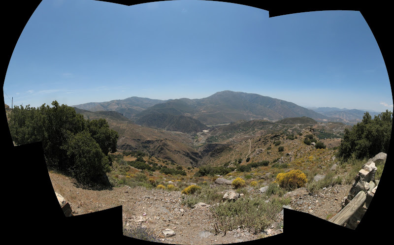
Friday, June 13, 2008
Finding some good tapas in Capiliera
Thursday, June 12, 2008
A mountain with an antenna
We had a plan today and that plan was to reach the antenna on the mountain we could see in the distance. We checked with David, looked at some maps and seemed doable, about 1600 meters of climbing on tarmac. David has been there before a few years ago and the only thing he remembered he wouldn't go back again, but in the end he went along to find out why. This is our target: 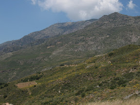
We leave Orgiva and head for the direction of Alcazar, the climb is on the road and it's hot, no wind and no shadow: in Belgium I would love that, but now I would love to feel some wind or have a little shadow, I solve this by turning around and descend a little bit to keep Thierry company.
The road climbs gradualy and is very quiet with nice surroundings until we reach the top of the pass, no descending yet for us, we turn to the road going up to the antenna, the road gets graduallly steeper but all manageable. 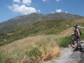
 We climb and climb, this piece seems to go on forever but finally everbody reaches the top, we have to wait on Thierry for a while, most of us already have eaten our lunch. Thierry tries to eat too, but his body decides that everything should go the otherway around and his breakfast departs with his body (this was the best description I could give ;-)
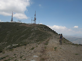
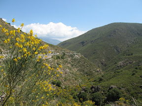
After this Thierry feels a lot better and we go searching for some tracks, and indeed we really need to search for the tracks. The maps says there is and indeed sometimes there is something that looks like a track...
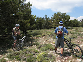
We reach a little forest, this is the most difficult part, the underground is rideable but the branches of the trees make it difficult to get through and most of this wood we have to walk, until we can finally ride and we find a jeep track. In our slang we call this 'berenjagen' or 'berenjacht' which translates directly as bear hunting...
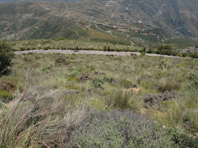
This jeep track gives us speed, but the track is rough with a lot of sharp stones and this makes our first victim: a flat tire for Thierry, while waiting we enjoy the scenery: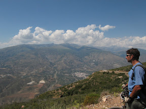
After regrouping however I have a snakebite again, only problem is that I was at the back and Steven didn't have a pump with him, I didn't have a pump, I only had a spare tire and the rest was gone. The only solution was that Steven rode to them and fetch a pump. In the meantime I walked down so that Steven didn't had to climb all the way and indeed about in the middle we met again. Repairing the tire didn't take long and we were on our way again, I got the 'advice' to take it easy which I also did. I didn't flat anymore, but Nicky did in the last part. In the end everybody made it down, no we only had to climb to Orgiva again and for some of us this was harder then expected... But in the end the beer and tapas made up for it.
Statistics:
Wednesday, June 11, 2008
Downhill...
Today plenty of downhill, we're headed back to Orgiva which means going from 2500 m above sea level to 400 m. But first we take a last look at Pico Veleta our not reached goal of yesterday. 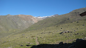 We'll be back !
 The downhill is not for free unfortunately, we first have to climb the only road leaving the refugio, this means the same climb of about 200 heightmeters again before we can start the descend.
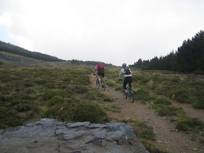
We start of on a wide jeep track which is a nice start of the descend to catch some speed. The track brings us back to the vegatation, soon we're back among the trees and not for long we're on a nice single track through the woods which brings us back to the entrance of the National Park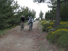
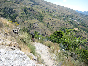
 Now a little bit of descending on the large dirt track being carefull for cars, after a 10 minutes descend we're at an interesting spot: a singletrack which cuts down more steeply down the mountain then the dirt track. Here starts some real fun, this trail starts out nicely, then we meet some walkers going up so we slow down a bit, say hello and let go of the brakes again for some interesting twists and turns and all to sudden we're on the tarmac again. We regroup and do the next cut-off, which has more of singletrack feeling with more vegatation. After regrouping again on the road again, I was ready to go for the next bit which would bring us back to Capiliera, but David said we're going to take another way to Capiliera which meant a little bit of climbing again. But it was worth it! This descend is very challenging, the underground is like a large rock wall on which you ride but the rock is not vertical, but lies more horizontally (lucky for us). During this descent I manage to go over the bars and kiss the ground with no severe injuries, just scratches on me and my ego. David 'Moots' on the other hand falls too, but he isn't so lucky and hurts his wrist badly, he can only use his one hand now. Lucky for us and him we're in Capiliera now, so we take a break for a drink.
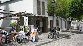
After the break 'Moots' decides to ride back home on the road, because he hardly can use his hand.
We on the other hand continue our descend over the nice singletracks, we pass Bubion to follow the GR7 down in the direction of Pampaneira which has some nice urban technical bits and back on the GR7 again to finish this bit at the power central.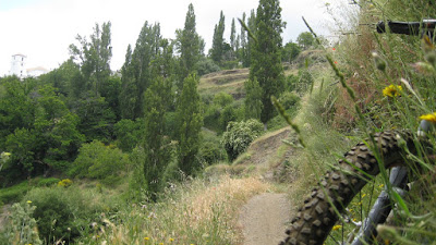
Now it's time again for a little bit of climbing, this time on the road. After 3 kilometers we leave the asphalted road again and find us some dirt tracks which will bring us back too Orgiva in a fast way.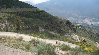
We end our day's ride again in the bar on the market in Orgiva for some well earned beer and tapas, this concludes our 3 day high altitude program.
Statistics: ... to come
Tuesday, June 10, 2008
Spain in June: snow...
Today is the big day: we're going to attack the Pico Veleta, at an height above sea level of 3394 meter; it will be a record breaking height (with the bike) for all of us. First thing I noticed today, it's cold: 6 C, that's rather cold but due to the fact that we starting with a climb, I decide to go for shorts and only arm warmers, which was a good decision. But before leaving I take the opportunity for a large panorama now that the sky is still void of clouds.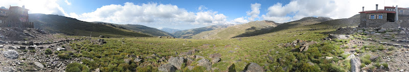
The first part of the climb we already know from yesterday, but yesterday we did it in the other direction which was faster and easier. Now this first part is hard work, and is the steepest we'll do today.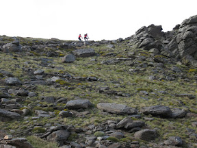 After this steep bit, the track continues where we stopped yesterday (in other words we're back at 2711 and ascended the descent of yesterday). From now on the road has a more comfortable rising grade, we continue climbing but regularly stop to absorb the scenery.
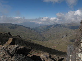
In this environment you don't expect too much people, but all of sudden we see in the distance a runner, and he's gaining ground on us. After a while he catches us and we see it's the Spanish guy from the refugio, in the evening we hear that he had run up Mulhacen.  . But our target for today is Pico Veleta, we pass the first snow easily and continue to follow to route at the foot of Mulhacen.
And the climbing continues steadily, no more vegetation at this height only rocks and a lost snow patch.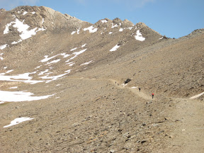 We pass an emergency refugio which is nothing more then four walls, a roof and some beds to provide you with the necessary shelter at this height, but we don't need it now luckily.
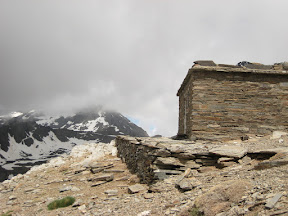
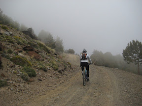
 Further up we can see the road carved in the mountain, the grade of the route is appealing: not steep just steady climbing; which is a good thing because of the height which has now broken the 3000m mark. At this altitude we ride continuously in the clouds, but it changes so quickly that we often see a small patch in the clouds and the sun shines on us. Finally we reach the hole in the mountain which gives us the easy access to the other side, Pico Veleta is not far anymore, we can almost though it.
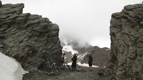
 After regrouping at this point we continue our route up, but
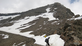
this snow patch is too large for my liking, so I stop and wait for the rest; Nicky however already starts the attack of the snow patch on the left side, which means 3 meters of snow on the right and a drop on the left of several meters, but after 5 meters she sees that it's undoable and sees I'm waiting.
I suggest to lunch here and returning back, too me it looked too dangerous to attempt this with the bike; certainly because further up we could so hikers struggling up on another snow patch. The group agrees and after lunch and after some picture taking moments, we put on some clothes and start the descend which will bring us back to the refugio. But I decide to snake bite my rear tire again, which is fixed in no time, finally we reach the refugio which is bathing in the sun.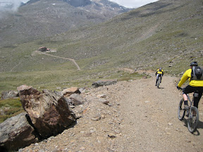 Arriving there we stride us all on the stairs and enjoy the scenery, sun and each others company, the rest of the evening is the same as yesterday: showering, drinking, resting, talking, eating, some more drinking, talking and finally sleeping.
Is was a lovily day today we didn't reach our goal, we stranded on 3130m; but no one is really disappointed, we all look at the bright side: we can come back to try it again...
More pictures
Statistics: 27.5 km
Height gain: 950 hm
Height profile: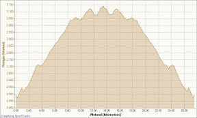
Monday, June 9, 2008
Andalacia day 4, the climb to the refugio
Today is the start of our High altitude program, the target is to reach the 3394 meters high Pico Veleta on the second day in this program, but first we need to get to the Refugio on 2500m.
At 11 o'clock David (yes yet another David) would come to fetch us and the bikes to bring us to Capileira, so the start of morning was relaxed no need to rush. David indeed arrived at 11, loading all our bikes in his van and away we were. After an 30 minute drive we arrived at Capileira: Height 1400, already 1000 height meters gained by doing nothing... David the guide parks his car safely for 3 days and after saying bye to David 'the driver' we're off into the direction of the National Park's entrance. The climb starts on asphalt and continues onto a wide gravel road, luckily the weather is a little overcast today so not too hot to climb. We make good progress, but stop regularly to enjoy the views. 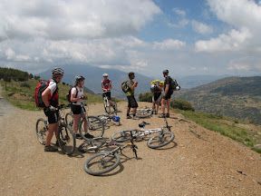 After a while we arrive at the entrance of the National Park, where we take the opportunity to take our lunch, but we're missing Nicky. Maybe she continued instead of stopping, so I go look for here, but don't find here directly, normally she wan't go that far in front, so I probably missed here and yes after returning to the lunchspot I hear she turned around the corner the moment I left, I suspect she has been waiting there all the time :-)
After our lunch we continue to ascend and we're getting really into the clouds.
 it's getting colder too, luckily the gradient of the climb stays stable, we pass the viewpont to Trevelez but due to the clouds we can't see that much and a little later we're at the highest point of today: 2711 meters.
Now it's descending to the Refugio which lies at about 2500 above sea level, but for this we need to climb twice, not much, but then out of nothing we see the refugio, finally we're there.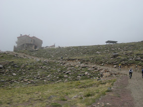 We place our bikes in the hallway, no fear of thieves here and go inside where the fireplace is the place to be. We order our first "Vino Caliente" and enjoy the place. At 7 o'clock dinner gets served, after some strange moving of furniture we can eat a nice 4 course menu. After dinner the clouds clear up a bit and have a nice view of the valley.
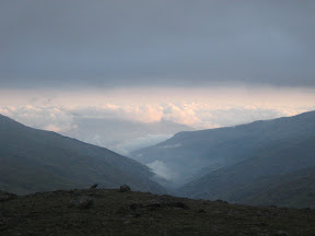 A little we go to sleep, which for some us seems harder to accomplish then for others, a loud snoring noise comes from one of the other dormetories...
Sunday, June 8, 2008
Andalucia day 3, the dam
Normally we this would have been the first day of our 3-days high altitude program, but the refugio was full for tonight, so we postponed it till tomorrow. We start our day via the main road out Orgiva in the direction of Lanjaron, but there's a lot of traffic of runners, today a running event is held in Orgiva and our timing is so bad we're just stuck behind it, luckily it's not too long before we turn offroad in the direction of Canar. This piece of the ride is hot, very hot. We're in the middle of an old river, so there's no wind, lot's of sun and the ground which radiates the heat back. After a while we hit the road, and I'm happy we're on tarmac now, this road climbs easy towards Canar, where we can fill our camelbaks and bottles.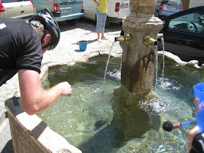
After our refill we ride through the streets of Canar in the direction of the GR7, a nice footpath which will lead us to the dam, here the pictures speak for themselves:

Unfortunaly I have a flat tire, at first I thought a snakebite due the speed it deflated; but after checking the tire I saw a slit of 2 cm a sharp stone has taken a bite of my tire and liked it.... During this reparation the rest could take a rest
 ,the footpath continues untill the dam
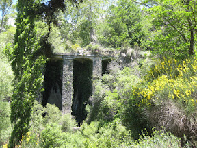
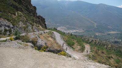
The descent continues on this GR7 footpath in the direction of Soportujar, where we descent further in the direction of Orgiva on some wider tracks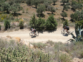 .
.
However before we are in Orgiva we take a the last small hill on our way, it's a nice singletrack ascent and descent. And the proof is there that the ascent is rideable to the top; Thierry showed us how to do it.
And as the day before this we end up on the main square of Orgiva for our apres-bike and tapas, and there is always something strange there: the pints of Thierry always seem to contain less then the rest of us...
Statistics:
21 km
900 hm
Total time: 4:37
Saturday, June 7, 2008
Day 2 of our vacation in Andalucia
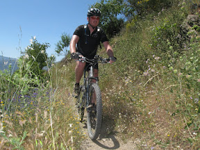
Today we have another small ride planned for today, this time we ride in the direction of Lanjaron. The climb is mostly on the road, just before Lanjaron we turn back in the direction of Orgiva on a steep asphalted road which turns in a jeep track later on. We enjoy 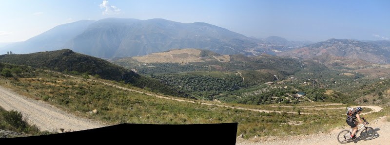 the scenery
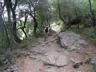
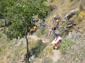
At the end of the climb we come to the highlight of this ride: technical singletrack downhill to Orgiva. This singletrack starts out nice with a wide singletrack with scattered rocks, not too fast not too slow.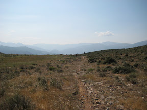 Three minutes later I spot a farm, a remember David saying please wait at the farm, I follow the track to find a suitable spot for a picknick
  . This was just the right spot to stop with a nice view of Orgiva and it's surroundings and a good look at the start of the gnarly section.
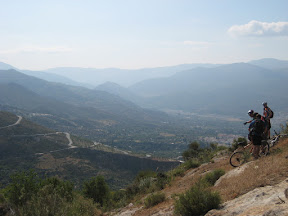
After our pick-nick we continue our descent, the singletrack now turns more technical with large stones and deep ruts, the descent also steepens a lot more then before  but the most of it stays rideable for me :-) But all good things come to the end and this time it means the downhill reaches it's lowest point. Time to reflect the downhill:
We end our's day riding with a tour around Orgiva to the main square we're we consume a drink a some tapas
Statistics:
20.16 km
700 height meters
Total time: 3 hours 25
Day 2 recovery training
This is the height-profile: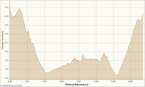 and this we call an recovery training :-) That's offcourse the trouble being in a hilly surroundings, you have to go up and down.
We went to the river to the place were we crossed it yesterday, there we just go along it up river till we had enough or we can't go any further. And indeed after a while we are at the end of the path, looking at the already travelled distance and time we decide we ride back, but first do some bear hunting so find another route back, which we find behind the trees.
Back at the house it's time again for olives and feta...
Statistics:
15.48
250 height meters
Total time: 1:50
Subscribe to:
Posts (Atom)